


Voting District 01, Surry County, North Carolina
About
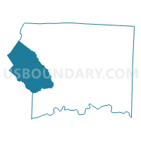
Outline

Summary
| Unique Area Identifier | 641460 |
| Name | Voting District 01 |
| County | Surry County |
| State | North Carolina |
| Area (square miles) | 69.48 |
| Land Area (square miles) | 69.13 |
| Water Area (square miles) | 0.35 |
| % of Land Area | 99.50 |
| % of Water Area | 0.50 |
| Latitude of the Internal Point | 36.40268860 |
| Longtitude of the Internal Point | -80.88173920 |
Maps


Graphs
Select a template below for downloading or customizing gragh for Voting District 01, Surry County, North Carolina


Neighbors
Neighoring Voting District (by Name) Neighboring Voting District on the Map
- Voting District 01, Alleghany County, NC
- Voting District 03, Surry County, NC
- Voting District 04, Alleghany County, NC
- Voting District 04, Surry County, NC
- Voting District 08, Surry County, NC
- Voting District 09, Surry County, NC
- Voting District 107, Wilkes County, NC
- Voting District 11, Surry County, NC
- Voting District 124, Wilkes County, NC
Top 10 Neighboring County Subdivision (by Population) Neighboring County Subdivision on the Map
- Dobson township, Surry County, NC (8,860)
- Edwards township, Wilkes County, NC (7,318)
- Elkin township, Surry County, NC (6,288)
- Traphill township, Wilkes County, NC (3,391)
- Bryan township, Surry County, NC (2,747)
- Marsh township, Surry County, NC (2,631)
- Franklin township, Surry County, NC (2,400)
- Glade Creek township, Alleghany County, NC (1,991)
- Cherry Lane township, Alleghany County, NC (1,528)
Top 10 Neighboring Unified School District (by Population) Neighboring Unified School District on the Map
- Wilkes County Schools, NC (69,340)
- Surry County Schools, NC (56,264)
- Alleghany County Schools, NC (11,155)
- Elkin City Schools, NC (6,291)
Top 10 Neighboring State Legislative District Lower Chamber (by Population) Neighboring State Legislative District Lower Chamber on the Map
Top 10 Neighboring State Legislative District Upper Chamber (by Population) Neighboring State Legislative District Upper Chamber on the Map
Top 10 Neighboring 111th Congressional District (by Population) Neighboring 111th Congressional District on the Map
Top 10 Neighboring Census Tract (by Population) Neighboring Census Tract on the Map
- Census Tract 9601, Wilkes County, NC (7,044)
- Census Tract 9310.02, Surry County, NC (5,216)
- Census Tract 9308.01, Surry County, NC (5,201)
- Census Tract 9309.01, Surry County, NC (4,467)
- Census Tract 9501, Alleghany County, NC (4,079)
- Census Tract 9602, Wilkes County, NC (3,836)
- Census Tract 9310.03, Surry County, NC (3,234)
- Census Tract 9308.02, Surry County, NC (3,176)
- Census Tract 9309.02, Surry County, NC (1,605)
Top 10 Neighboring 5-Digit ZIP Code Tabulation Area (by Population) Neighboring 5-Digit ZIP Code Tabulation Area on the Map
- 28621, NC (10,472)
- 27017, NC (9,597)
- 28676, NC (3,483)
- 27024, NC (2,733)
- 28683, NC (1,697)
- 28623, NC (1,653)
- 28627, NC (1,152)
- 28668, NC (300)